Targets Localization from Drone
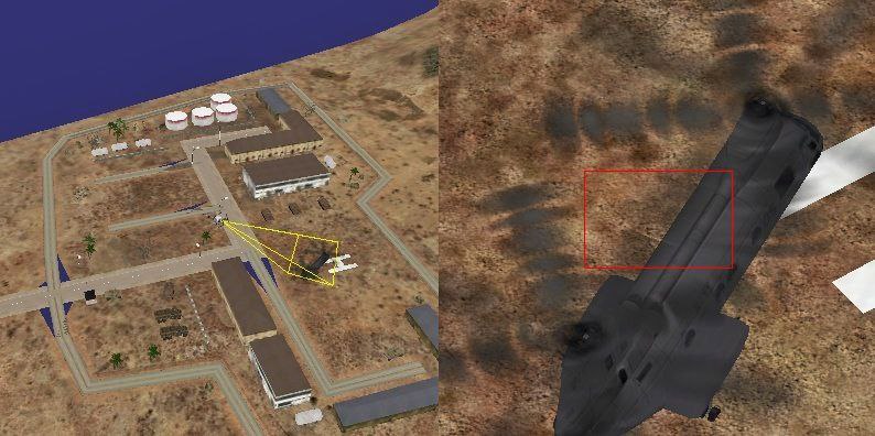
In the context of drone simulations, vsTASKER by VirtualSim is a powerful visual scenario editor and C++ code-generation framework used to model autonomous UAV target localization.The primary objective of this specific implementation is extracting accurate ground target coordinates using a simulated flying quadcopter equipped with a payload-mounted camera and an AI image analyzer.Core Mechanics of vsTASKER Target Localization To build a target localization project in vsTASKER, the system architecture maps out the technical pipeline across four critical phases:[3D Terrain/Map] ➔ [Drone Sensors/Gimbal] ➔ [AI Image Analyzer] ➔ [Mathematical Localization]

1. Terrain and Environmental Modeling3D Databases: The system uses standard spatial formats (like OpenSceneGraph or osgEarth databases) to build a high-fidelity 3D map environment.

Line of Sight (LOS): vsTASKER evaluates real-time line-of-sight metrics between the drone and the ground target, as elevation maps heavily influence target tracking accuracy.

2. Sensor and Payload Simulation Kinematics : The platform simulates the physics-based flight profiles of the quadcopter, incorporating dynamic flight variables like velocity, heading angles, and altitude.Gimbal/Camera Logic: The payload camera captures high-definition frames. It tracks variables like focal length, camera orientation (pitch/yaw/roll), and instantaneous fields of view (FOV).
Perception via AI Image AnalysisDetection & Target Locking:

The simulation incorporates object-detection algorithms (e.g., template matching or bounding boxes) to identify and distinguish targets from the background environment.

Pixel to Coordinate Translation: Once locked, the software calculates the pixel offset of the target relative to the center of the camera view.

4. The Geolocation Extraction FormulaBecause the drone may not use active laser ranging (relying instead on safer passive localization), it applies geometric and statistical methods:Ray-Casting Intersections: The software casts a vector from the camera's 3D origin, through the target's image pixels, to calculate where it intersects the 3D triangular mesh of the terrain map.

Batch Scenario Validation: Users can utilize vsTASKER's batch execution capability to chain thousands of high-speed runs. This allows developers to tweak parameters like payload rotation speed, camera quality, or wind vibration to calculate the exact probability and circular error probability (CEP) of detection.
Reference video showing features of vsTASKER
When comparing Target Localization for actual drone operations to vsTASKER, the primary difference is implementation vs. simulation. The first is a real-world technological challenge for physical autonomous drones, while vsTASKER is a software platform used to plan, test, and simulate those exact missions.Target Localization (Real-World Use Cases)Real-world target localization relies on a drone’s onboard hardware and software stack to calculate the precise GPS coordinates of a person, vehicle, or point of interest.

Sensors & Vision: Drones use gimballed cameras, thermal cameras, and AI image analysis to spot the target.Math Involved: The drone uses its GPS, altitude, and camera angles to run Geo-Location mathematical algorithms.Applications: Search and rescue, precision agriculture, railway inspections, and tactical military mission
Downlaod - Targets Localization from Drone
Request for Trial licence
Download User Guide & reference manual
vsTASKER (Simulation & Management Platform)vsTASKER is a graphical simulation engine developed by VirtualSim. It creates synthetic environments (Digital Twins) to test drone behavior and localization algorithms without needing to fly a real drone.Scenario Testing: You can place a "virtual" drone and targets in 2D or 3D terrain and build the drone's logic, such as search patterns and obstacle avoidance.Hardware-in-the-Loop: Instead of real-world flying, vsTASKER simulates the payload, camera feed, and AI logic to extract coordinates and test system accuracy.Batch Testing: It allows developers to run thousands of virtual runs automatically to see how environmental changes (wind, terrain, lighting) affect a drone's ability to lock onto a target